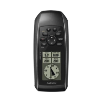
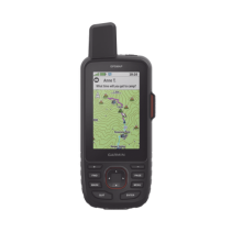
GPS portátil GPSMAP 65 con pantalla a color, almacenamiento interno de hasta 5,000 puntos, memoria interna de 16 GB, resistente…
195923
GPS Garmin GPSMAP 65 con pantalla a color de 2.6”, 16 GB de memoria expandible y diseño resistente al agua IPX7. Ideal para aventuras al aire libre.
 Security policy
(edit with the Customer Reassurance module)
 Delivery policy
(edit with the Customer Reassurance module)
 Return policy
(edit with the Customer Reassurance module)